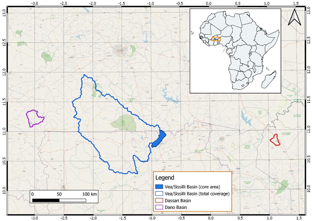
Watersheds with rich hydro-meteorological equipment are essential for an improved analysis of environmental changes and their impacts in West Africa – a region characterized by severe land cover change due to strongly increasing demand for agricultural land. Accordingly, WASCAL has established local hydro-climate observation networks in three watersheds– also known as basins – in the semi-arid Sudanian zone of West Africa, specifically in the Dassari (Benin), Dano (Burkina Faso), and Vea/Sissilli (Ghana/Burkina Faso) watersheds. These basins (see the Figure below) represent the core research base (i.e., experimental catchment) for scientists involved in WASCAL-related research activities in West Africa, particularly those interested in studying the semi-arid Sudanian zone.
The basins which form the novel research observatory of WASCAL are equipped with several environmental monitoring (i.e., climate, soil-water, river gauging, river flow, turbidity, and piezometric) stations and is designed for long-term measuring of more than 30 hydrometeorological variables in sub-hourly temporal resolution and further variables such as carbon dioxide.
Past and ongoing research projects in these basins can be broadly categorized into the following thematic areas – climate, hydrology, agronomy, and land use. At the Vea Basin, for example, a micro-meteorological field experiment using eddy covariance stations has been implemented in contrasting sites (near-nature, cropland, and degraded grasslands) to assess the impact of land cover changes on water, energy, and carbon dioxide fluxes.
Dassari Basin
Located near Tanguiéta in Benin, the Dassari Basin is equipped with numerous hydro-meteorological sensors which have been collecting data since 2013. The basin is a portion of land identified and characterized by WASCAL in 2012 for its research work. It is located in the neighborhood of Materi in the Atacora district of Benin. Covering an area of 200 km2, it has been delimited so that no external water enters it, and all its rivers converge towards the Pendjari park which is located completely downstream of the basin and which is thus considered to be its outlet. It has a little rugged relief which ensures a slow flow in the main rivers. As a result, the Dassari basin straddles the Pendjari park and a part of the neighborhoods of Materi and Tanguiéta. This gives the basin the advantage of having both a Controlled Occupation Zone and a disturbed area due to the vast array of anthropogenic activities by residents of the nearby villages.
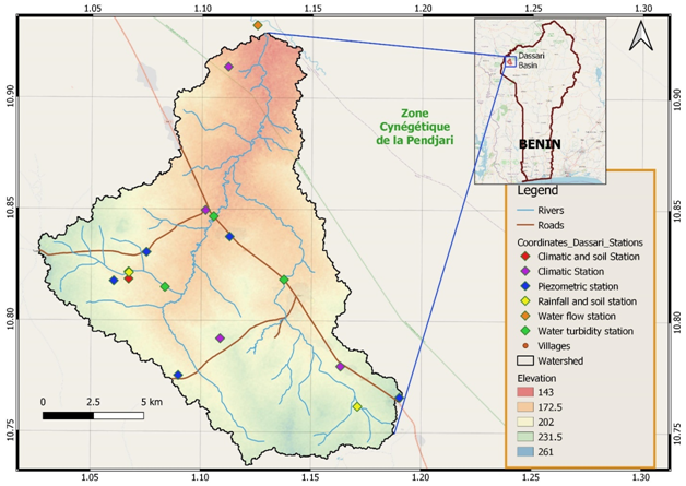
The basin is characterized by a Sudano-Guinean type climate, with auni-modal rainfall pattern characterized by two distinct seasons. The dry season is generally from November to April. It is marked by a dry and cool wind, also known as the harmattan, which originates from the Sahara between November and February on the one hand, and by a period of strong heat (March and April) on the other hand. The rainy season which largely determines the local agricultural calendar generally runs from May to October with occasional pockets of drought. The rains, which are unequally distributed over the period, are set in July and heavy rainfall is observed in August and September. Maximum daily temperature within the basin varies between 34 and 40° C, with an average temperature of about 27 ° C. However, average temperature during the cooler months (November, December, and January) is around 19° C.
The main river that waters the neighborhood of Materi is the Pendjari River. An arm of this river called Boualapora with its tributaries respectively at Houangou (that of Nagasséga) and Boualahon (that of Dassari), are the main water bodies that water the Dassari Basin. Most of these rivers (except Pendjari) are temporary because they dry up very quickly during the dry season due to intensive deforestation around the banks. However, in some places where the banks have wooded cover, pockets of water may remain. Thus, the Pendjari River is the only watercourse that forms a South, East, North, and West loops. It joins a tributary of the Volta to the west of the basin in the Tampaga regions to form Oti in Togo before flowing into the Volta in Ghana.
The activities in this basin are coordinated by Mr. Adolphe SetondjiAvocanh (avocanh.a@wascal.org).
Dano Basin
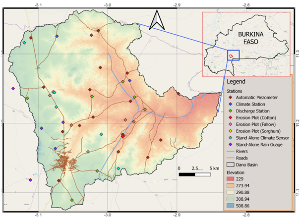
The Dano Basin is one of WASCAL’s core research catchments equipped with numerous hydro-meteorological sensors and is located near Dano in the Loba Province of Burkina Faso. The basin, which covers a total area of 195 km2, encompasses a micro stream that belong to the large Mouhoun Basin (Black Volta). In addition, there are several streams which dry up in the dry season.
The Dano basin is part of the transition zone between the Sudano-Sahelian zone (600-900mm/year precipitation) and the Sudanian zone (900-1200mm/year precipitation). The climate over the catchment is characterized by two distinct seasons: a rainy season (May to October) and a dry season (November to April). The climate regime is regulated by the oscillation of the Intertropical Convergence Zone (ITCZ) front which is driven by the Sahara anticyclone and the Southern Hemisphere anticyclone. The annual mean temperature in the catchment equals 28°C with monthly mean values varying between 24°C and 32°C.
The natural vegetation in the basin is made up of tree species and herbaceous stratum, the majority of which has been converted to agriculture and long-term fallowing during the past decades. The dominant crops are sorghum, cotton, maize, millet, rice (produced in inland valleys), cowpeas, groundnut, and sesame. A distinctive feature of Dano (and the south-western part of the country) is the intensive use of firewood to produce the local beer “dolo”, which constitutes an additional driver to the degradation of the natural vegetation.
Like the other basins, the Dano basin is equipped with complete climate stations (8), stand-alone climate sensors (28) and rain gauges (5), piezometers (27), and discharge stations (16). Moreover, WASCAL has established three experimental sorghum, fallow, and cotton plots (each of which is equipped with a water pump, sample splitter, water barrels, and an electrical power in their form of solar or power generator) for soil erosion investigation.
The activities in this basin are coordinated by Mr. Hamadou Barro (barro.h@wascal.org).
Vea/Sissilli Basin
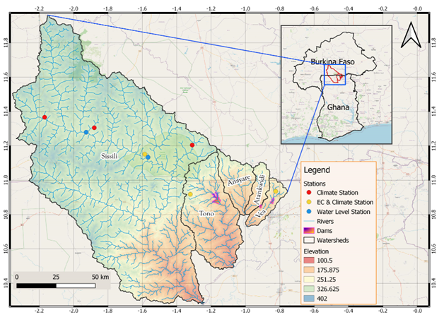
The Vea/Sissilli Basin collectively represents five (5) watersheds including the Vea, the Sissili, the Tono, the Atankwedi and the Anayare river basins. The basin which covers parts of northern Ghana and southern Burkina Faso is one of the three focal experimental catchments of WASCAL with Vea watershed (about 300 km2 in surface area) being its core research area. The basin comprises several wetlands, inland valleys, small dams (used for irrigation and animal watering) and wells/pumps resulting which makes it a complex ecosystem.
The climate of the basin is driven by West African Monsoon (WAM) and can be separated according to the WAM stages into a dry season (December to February), rainy season (July to September) and two transitional periods. Annual precipitation in the basin ranges between 800 mm and 1100 mm and originates largely from mesoscale convective systems. Therefore, precipitation amounts are characterized by a high spatiotemporal and multi-decadal variabilities. Land cover in the basin is undergoing rapid change exacerbated by increasing food demand of the considerably growing population of communities in the area.
The activities in this basin are coordinated by Mr. Samuel Guug (guug.s@wascal.org).