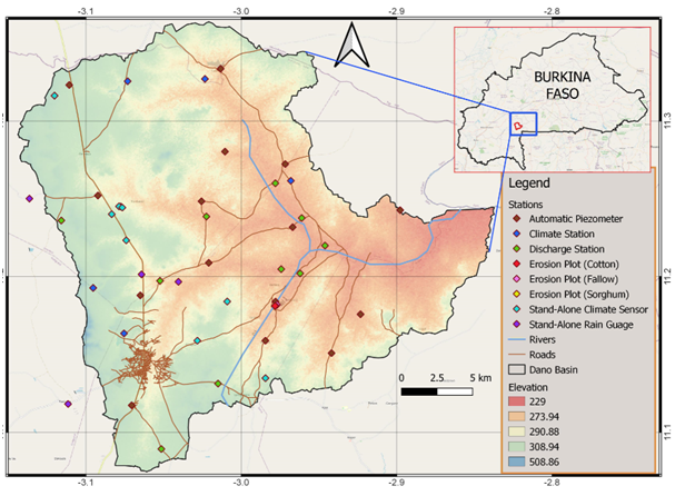
The Dano Basin is one of WASCAL’s core research catchments equipped with numerous hydro-meteorological sensors and is located near Dano in the Loba Province of Burkina Faso. The basin, which covers a total area of 195 km2, encompasses a micro stream that belong to the large Mouhoun Basin (Black Volta). In addition, there are several streams which dry up in the dry season.
The Dano basin is part of the transition zone between the Sudano-Sahelian zone (600-900mm/year precipitation) and the Sudanian zone (900-1200mm/year precipitation). The climate over the catchment is characterized by two distinct seasons: a rainy season (May to October) and a dry season (November to April). The climate regime is regulated by the oscillation of the Intertropical Convergence Zone (ITCZ) front which is driven by the Sahara anticyclone and the Southern Hemisphere anticyclone. The annual mean temperature in the catchment equals 28°C with monthly mean values varying between 24°C and 32°C.
The natural vegetation in the basin is made up of tree species and herbaceous stratum, the majority of which has been converted to agriculture and long-term fallowing during the past decades. The dominant crops are sorghum, cotton, maize, millet, rice (produced in inland valleys), cowpeas, groundnut, and sesame. A distinctive feature of Dano (and the south-western part of the country) is the intensive use of firewood to produce the local beer “dolo”, which constitutes an additional driver to the degradation of the natural vegetation.
Like the other basins, the Dano basin is equipped with complete climate stations (8), stand-alone climate sensors (28) and rain gauges (5), piezometers (27), and discharge stations (16). Moreover, WASCAL has established three experimental sorghum, fallow, and cotton plots (each of which is equipped with a water pump, sample splitter, water barrels, and an electrical power in their form of solar or power generator) for soil erosion investigation.
The activities in this basin are coordinated by Mr. Hamadou Barro (barro.h@wascal.org).