
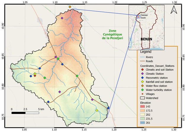
Located near Tanguiéta in Benin, the Dassari Basin is equipped with numerous hydro-meteorological sensors which have been collecting data since 2013. The basin is a portion of land identified and characterized by WASCAL in 2012 for its research work. It is located in the neighborhood of Materi in the Atacora district of Benin. Covering an area of 200 km2, it has been delimited so that no external water enters it, and all its rivers converge towards the Pendjari park which is located completely downstream of the basin and which is thus considered to be its outlet. It has a little rugged relief which ensures a slow flow in the main rivers. As a result, the Dassari basin straddles the Pendjari park and a part of the neighborhoods of Materi and Tanguiéta. This gives the basin the advantage of having both a Controlled Occupation Zone and a disturbed area due to the vast array of anthropogenic activities by residents of the nearby villages.
The basin is characterized by a Sudano-Guinean type climate, with auni-modal rainfall pattern characterized by two distinct seasons. The dry season is generally from November to April. It is marked by a dry and cool wind, also known as the harmattan, which originates from the Sahara between November and February on the one hand, and by a period of strong heat (March and April) on the other hand. The rainy season which largely determines the local agricultural calendar generally runs from May to October with occasional pockets of drought. The rains, which are unequally distributed over the period, are set in July and heavy rainfall is observed in August and September. Maximum daily temperature within the basin varies between 34 and 40° C, with an average temperature of about 27 ° C. However, average temperature during the cooler months (November, December, and January) is around 19° C.
The main river that waters the neighborhood of Materi is the Pendjari River. An arm of this river called Boualapora with its tributaries respectively at Houangou (that of Nagasséga) and Boualahon (that of Dassari), are the main water bodies that water the Dassari Basin. Most of these rivers (except Pendjari) are temporary because they dry up very quickly during the dry season due to intensive deforestation around the banks. However, in some places where the banks have wooded cover, pockets of water may remain. Thus, the Pendjari River is the only watercourse that forms a South, East, North, and West loops. It joins a tributary of the Volta to the west of the basin in the Tampaga regions to form Oti in Togo before flowing into the Volta in Ghana.
The activities in this basin are coordinated by Mr. Adolphe SetondjiAvocanh (avocanh.a@wascal.org).